This article first appeared in Irrigatin New Zealand’s Quarterly magazine in 2012.
Hew Dalrymple says mapping maize yields with his combine harvester highlighted problems with water in his paddocks: some parts had too much and some had too little. Hew and brother, Roger, now have 20 pivot irrigators at Waitatapia, their 2400ha Manawatu sand country farms. And a comprehensive drainage programme as well.
Soils at Waitatapia are low-lying, deep sands in flat to undulating contour. Crops often suffer yield loss due to drought stressed dune tops, a high water table and ponding in depressions.
An integrated irrigation and drainage programme is in train, using high-tech land-levelling and drainage, centre pivots and precision irrigation.
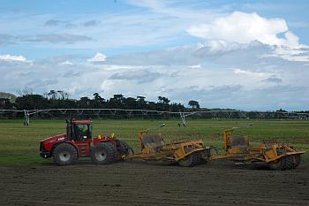
Land-levelling, or re-contouring, aims to even out the soil pattern and change the contours to gently rounded or more flattened slopes which follow the natural lie of the land. Elevation data collected on-farm with high accuracy GPS is fed into a software package that identifies best cut-and-fill options. A 560hp tractor and two large GPS controlled scrapers do the work. In effect, the tops are put in the hollows, and a median grade established.
The re-contouring is complemented by a surface drainage network, also installed with the help of GPS. “We need to be careful with open drains in sand, but it is a critical part of our infrastructure,” says Hew.
Water for irrigation comes from the Rangitikei River. Gravity helps deliver it to the and through the farm, greatly reducing energy costs. Pivots are the only realistic method given the soil type and scale of operation. But they do have limitations.
Several belts of pine forested sand dunes prevent pivots from completing full irrigation circles. In several places dunes have been removed to increase the arc and irrigated area.
Because some areas under the pivots still have wet spots or drains requiring no irrigation, Hew has invested in three variable rate systems.
Mapping with electromagnetic (EM) sensors and GPS logging helped identify variable soil zones. “We’ve got a clear picture of the lower wet spots and the higher dry spots, and they correspond to our yield maps.” Carolyn Hedley at Landcare Research turned the EM maps into soil water holding capacity maps. These were used to design and manage the VRI system.
The Dalrymples use a soil-moisture measurement service to help schedule irrigation. Light soils, variable weather, a high water table and capillary rise make careful scheduling essential. “We are also using EM survey information to select positions for soil moisture probes. That way, they will best represent the range of soil characteristics and drainage patterns,” says Hew.
So water management at Waitatapia is more than irrigation. Hew says, “It is about using water, nutrients and energy in better ways. Better soil water management equals better nutrient management. We invest a fair amount in irrigation. We don’t want to pay a big power bill to over-water and flush nutrients through the soil profile.”
“It is a big, expensive, integrated programme, but introducing irrigation and managing drainage has massive benefits for production and confidence,” says Hew. “The soils here are very light, but with good management they grow crops and pasture amazingly well.”