We initially used OptiSurface to create cut and fill maps for land shaping to avoid surface ponding problems. We quickly saw the power of OptiSurface to analyse surface flows and assess the risk of soil erosion.
One feature of OptiSurface is its ability to analyse storm events. We enter 1 hour and 24 hour rainfall data (for example for a 1 in 10 year rain event) and OptiSurface mimics a storm that floods the farm and calculates how water will move across its surface. Outputs include water velocity and depth.
Water velocity is important as it is the main factor determining the energy for soil erosion. While every case is different, a rule of thumb for cultivated soils is a critical velocity of 0.5m/s (“Drainage of Irrigated Lands”, FAO Training Manual 9, p.51.). Above the critical velocity, soil particles will be detached and wash away. An idea of the range of critical velocities is provided below (from “Soil Erosion” by D. Zachar, 1982.).
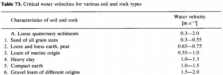
Critical velocities for assessing risk of soil erosion. Part of Table 73 from D Zachar 1982
Water depth is important as the volume of water (depth times width) determines how much sediment can be carried. Importantly, as the water volume increases, the amount of sediment it can carry increases much, much faster. Doubling flow might cause a 20-50 times increase in sediment transport!